Freeway Traffic Intelligence
That Works in Any Weather.
How 3D LiDAR delivers the lane-by-lane speed, volume, occupancy, and vehicle classification data that adaptive ramp metering systems depend on — continuously, accurately, and without pavement cuts or weather sensitivity.
Traffic congestion on freeways doesn’t just slow commutes — it costs economies billions of dollars annually in lost productivity, increased fuel consumption, elevated emissions, and higher collision rates. Transportation agencies have known for decades that the most cost-effective intervention isn’t building more lanes. It’s using the capacity that already exists more intelligently.
Adaptive ramp metering is one of the most proven tools in that intelligence toolkit. By controlling the rate at which vehicles enter a freeway from on-ramps, ramp metering smooths the merge process, prevents the sudden speed drops that trigger congestion waves, and keeps mainline traffic flowing at stable, efficient speeds. Studies consistently show measurable reductions in peak-period travel times, fewer rear-end collisions, and improved corridor throughput where ramp metering is properly implemented.
But there is a critical dependency buried in every adaptive ramp metering algorithm: real-time, lane-by-lane freeway data. Vehicle speed, volume, occupancy, and classification — updated within fractions of a second, for every lane, continuously. When that data is accurate, ramp metering algorithms make intelligent decisions. When it isn’t, they either over-restrict on-ramp access and create unnecessary backups, or under-restrict it and allow the mainline breakdown they were designed to prevent.

Freeway congestion is predictable and preventable — with the right real-time detection data feeding adaptive ramp metering systems
Adaptive ramp metering is only as intelligent as the data feeding it. Lane-by-lane vehicle speed, volume, occupancy, and classification — updated in fractions of a second — is not a nice-to-have. It is the foundation on which every metering decision rests.
What Ramp Metering Needs — and Why Traditional Sensors Struggle to Deliver It
An adaptive ramp metering system continuously monitors freeway conditions and adjusts on-ramp signal timing in real time to match entry rates to available mainline capacity. To do this well, it needs data that is accurate, comprehensive, and current — not estimates, not averages, not data that degrades in poor weather.
Specifically, the system requires for each monitored freeway lane: instantaneous vehicle speed, volume counts per defined time interval, lane occupancy percentage, vehicle length classification, and the ability to detect congestion onset before it propagates upstream. Traditional detection technologies have served this need adequately in ideal conditions — but each has structural limitations that become operationally significant in real-world freeway environments.
Inductive Loop Detectors — Accurate But Fragile
Loops remain a workhorse of freeway detection and deliver reliable data when functioning correctly. But they require pavement cuts to install, are vulnerable to road deterioration, resurfacing, and freeze-thaw damage, and require lane closures for maintenance. On a high-volume freeway corridor, a failed loop in a critical lane can compromise metering decisions for hours before it is identified and addressed.
Microwave Radar — Good Speed Data, Limited Classification
Radar sensors excel at measuring vehicle speed and perform well in adverse weather, making them a common complement to loop detectors. However, radar typically infers vehicle length classification indirectly and can struggle with closely spaced vehicles, multiple vehicles in the detection zone simultaneously, and reliable detection across wide multi-lane configurations from a single roadside installation.
Video Analytics — Powerful But Weather-Dependent
Machine learning-powered video detection has advanced significantly and can extract rich lane-by-lane data under good conditions. But camera performance degrades measurably in rain, snow, fog, darkness, headlight glare, and direct sun — all conditions that occur regularly on Canadian freeways and that often coincide with the peak demand periods when accurate ramp metering data matters most.
Occlusion and Multi-Lane Coverage Limitations
On freeways with six, seven, or eight lanes, covering all lanes from a single roadside installation is challenging for many conventional sensor types. Large trucks can shadow adjacent lanes from side-mounted sensors. Closely spaced vehicles can register as a single detection event. These errors are small individually but accumulate into occupancy drift that causes metering algorithms to make systematically poor decisions.
How 3D LiDAR Changes Freeway Detection
A 3D LiDAR sensor installed on a roadside pole or overhead gantry above a freeway builds a continuous, real-time three-dimensional map of every vehicle in its detection zone. It doesn’t ask whether a vehicle broke a detection threshold — it tracks every vehicle as a unique three-dimensional object with its own precise position, velocity, heading, length, and width from the moment it enters the detection zone to the moment it exits.
This is a fundamentally different approach to detection. Rather than inferring vehicle characteristics from a signal change at a fixed point, LiDAR directly measures them across the full detection zone in real time. The result is data that is more accurate, more comprehensive, and more robust than any point-sensor technology — simultaneously, for all lanes, from a single installation.
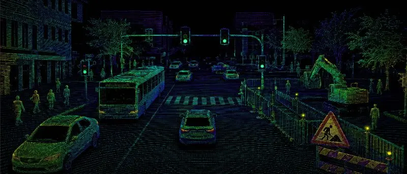
LiDAR sees every vehicle across all lanes simultaneously — tracking position, speed, and classification in real time
For ramp metering applications, this means the metering algorithm receives a continuous, lane-by-lane feed of speed, volume, occupancy, and vehicle classification data — updated fast enough to detect the early signatures of congestion onset before speeds drop significantly. Early detection is the difference between proactive metering that prevents breakdown and reactive metering that only responds after the damage is done.
LiDAR operates independently of ambient lighting and maintains consistent performance in rain, snow, fog, darkness, and glare. For freeway operations in Canada, this is not a minor feature advantage — it is the difference between a detection system that works and one that fails precisely when accurate data is most critical.
LiDAR Freeway Traffic Detection — Live Demo
Watch LiDAR track and classify vehicles across multiple freeway lanes in real time.
LiDAR detecting and classifying vehicles across multiple freeway lanes simultaneously
The Data LiDAR Delivers for Ramp Metering
A properly deployed LiDAR freeway detection system provides everything adaptive ramp metering algorithms need — and more that traditional sensors simply cannot deliver.
Lane-by-Lane Vehicle Speed
Instantaneous and time-averaged speed for every vehicle in every lane. Detects speed differentials between adjacent lanes — an early indicator of lane-specific congestion developing before it becomes a network-wide breakdown. Accuracy within ±2 km/h across all speed ranges.
Volume Counts per Lane
Precise vehicle counts per lane per configurable time interval — 20 seconds, 1 minute, 5 minutes — delivered to the traffic management centre in real time. Counts are based on tracked objects, not signal interruptions, eliminating the miscounting that affects point sensor technologies at high volumes.
Lane Occupancy
The percentage of time each lane is occupied by vehicles — the metric most directly correlated with congestion onset and the primary input for most adaptive ramp metering algorithms. LiDAR measures occupancy directly from tracked object presence, not from estimated axle spacing or signal duration.
Vehicle Length Classification
Every detected vehicle is classified by length into configurable categories — motorcycles, passenger vehicles, light trucks, single-unit heavy vehicles, and multi-unit heavy vehicles. This enables classification-specific metering strategies that account for the different merging characteristics and space requirements of heavy vehicles versus passenger cars.
Congestion Onset Detection
By tracking speed trends and occupancy changes continuously across all lanes, LiDAR enables the detection of congestion onset signatures — the speed reduction and occupancy increase patterns that precede full breakdown — typically 2 to 5 minutes before conditions deteriorate to the point that recovery becomes difficult. This lead time is precisely what proactive ramp metering requires.
Direct Integration with Traffic Management Systems
LiDAR detection data is delivered via standard ITS communication protocols — NTCIP, UTMC, or proprietary API — to traffic management centres, adaptive ramp metering controllers, and corridor management platforms. Integration with existing infrastructure does not require replacing control systems — it enhances the quality of data they receive.
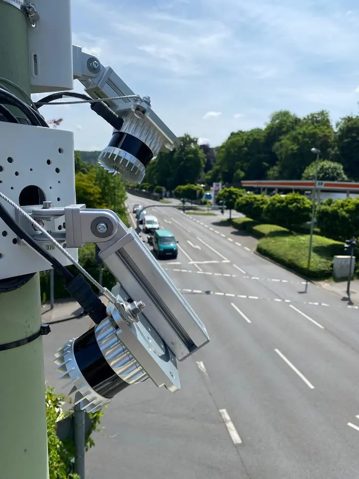
One Sensor. Up to Eight Lanes. Any Weather.
Our freeway LiDAR detection units are built for permanent outdoor deployment — IP-rated, temperature-rated for Canadian winters, and designed for roadside or overhead gantry mounting without lane closures or pavement modification.
A single unit covers up to eight freeway lanes simultaneously, with a detection range that captures vehicles well upstream of the sensor position — providing the advance detection time that allows congestion onset algorithms to respond before conditions deteriorate.
How Better Data Translates to Smarter Metering Decisions
The connection between detection quality and metering performance is direct. Ramp metering algorithms calculate entry rates based on the gap between current mainline occupancy and the target occupancy threshold — typically around 70-75% before congestion risk increases significantly. When occupancy data is accurate, the algorithm sets entry rates that keep the mainline just below that threshold. When it isn’t, the system oscillates — alternating between over-restriction and under-restriction in ways that reduce both ramp throughput and mainline stability.
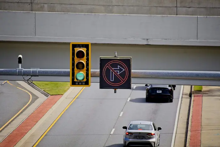
Ramp metering signals control mainline entry — accurate lane-by-lane data is what makes the algorithm intelligent
LiDAR’s contribution here is not complexity — it is precision. More accurate occupancy data means tighter algorithm control, which means the mainline operates closer to its theoretical capacity for a larger portion of the peak period. In practical terms, this translates to higher corridor throughput, reduced peak-period travel times, and fewer secondary incidents caused by sudden speed changes in congested traffic.
Vehicle classification data adds a further dimension. Heavy vehicles require longer gaps to merge safely and occupy more space on the mainline. A metering system that knows the proportion of heavy vehicles in the current traffic stream can adjust headway requirements at the ramp signal to account for this — preventing the merge conflicts that are a disproportionate cause of freeway rear-end collisions.
Transportation agencies that have upgraded freeway detection for adaptive ramp metering report consistent improvements in peak-period mainline speeds, reductions in congestion duration, and lower collision rates at merge points. The technology investment is modest relative to the infrastructure it optimises — better data from existing ramp metering infrastructure delivers measurable returns without major capital expenditure.
Beyond Ramp Metering — Freeway Corridor Intelligence
LiDAR freeway detection delivers value that extends well beyond the ramp metering application. The same lane-by-lane vehicle data that feeds metering algorithms also supports a range of other freeway operations and planning functions — making each sensor deployment a multi-purpose infrastructure investment.
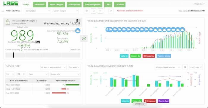
LiDAR data feeds traffic management centre dashboards with live lane-by-lane speed, volume, and classification
🚨 Incident Detection
Sudden speed drops, stopped vehicles, and wrong-way detections trigger automated alerts to traffic operations centres — enabling faster response to incidents before secondary collisions occur.
📡 Variable Message Signs
Real-time speed and travel time data feeds dynamic message sign systems — giving drivers accurate corridor information and supporting speed harmonisation during congestion periods.
🛣️ Corridor Performance Monitoring
Continuous historical data enables robust before/after studies, seasonal performance analysis, and the evidence base for infrastructure investment and operational change decisions.
📦 Freight & Heavy Vehicle Monitoring
Classification data supports freight corridor management — identifying heavy vehicle volume patterns, peak periods, and lane utilisation for goods movement planning and road design.
🔗 Connected Vehicle Integration
LiDAR detection data can be published to connected vehicle infrastructure platforms — providing real-time freeway condition data to equipped vehicles and third-party navigation applications.
📊 Planning & Environmental Reporting
Vehicle classification counts by lane support emissions modelling, environmental assessments, and the traffic data submissions required for planning approvals and corridor environmental studies.
“The best freeway management systems in the world are constrained by the quality of their detection data. LiDAR removes that constraint — delivering the lane-by-lane precision that adaptive algorithms need to perform as designed.”
— Smart Sensor Solutions
Why Transportation Agencies Are Choosing LiDAR for Freeway Detection
- Up to 8 lanes from one sensor — reduces installation count and infrastructure complexity versus per-lane point sensors
- No pavement cuts required — roadside or gantry mounting eliminates lane closures for installation and maintenance
- All-weather, all-lighting operation — consistent performance in rain, snow, fog, darkness, and glare that degrades camera systems
- Direct vehicle measurement — speed, length, and occupancy measured from tracked 3D objects, not inferred from signal characteristics
- Vehicle length classification — passenger vehicles, light trucks, and heavy vehicles classified in real time for every lane
- Sub-second data latency — detection-to-output delay fast enough for adaptive algorithm response to congestion onset signatures
- Standard ITS protocol output — NTCIP and UTMC compatible, integrates with existing traffic management centre infrastructure
- Multi-application value — the same sensor supports ramp metering, incident detection, VMS feeds, and corridor performance monitoring
- Long service life — no moving parts, ruggedised housing, rated for Canadian winter conditions
Every freeway corridor already has significant infrastructure investment in ramp metering hardware, traffic management systems, and communications networks. LiDAR detection does not replace that investment — it maximises the return on it by providing the accurate, continuous, all-weather data that makes every downstream algorithm and operator decision more effective.
Ready to Upgrade Your Freeway Detection?
Whether you are evaluating LiDAR for a new ramp metering corridor, replacing ageing loop detectors, or expanding an existing detection network — we are ready to scope your project.
Serving transportation agencies across Canada and the United States · Tel: +1 (855) 613 4486 · info@smartsensrsolutions.com