Full Touchpoint Coverage,
One Continuous Journey:
Real-Time Passenger Flow with LiDAR.
Restrooms, lounges, queues, curbside, gates — a passenger crosses dozens of touchpoints on the way through a terminal. LiDAR is the only sensing technology that can follow that journey continuously and feed it into one live digital twin.

LC.3.0 Pro

LC.3.0 Pro Max
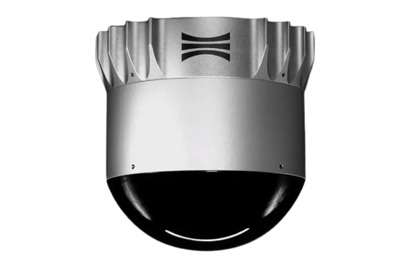
The Dome
Every terminal already has cameras. What most terminals don’t have is a system that can tell you, at 2:47 PM on a Tuesday, exactly how many people are in the north restroom bank, how long the average dwell time at Gate B34 has been over the last hour, and whether the queue building at security is going to breach an acceptable wait time in the next fifteen minutes — all without a human watching a single screen.
That capability has a name: a live digital twin. Not a static 3D model of a terminal used for planning meetings, but a continuously updated spatial replica — populated in real time with the actual position, path, dwell time, and occupancy of every person, vehicle, and object moving through the building. It’s the layer that turns “we think the west checkpoint gets backed up around lunch” into a dashboard that shows it happening, predicts it before it happens, and lets an operations team act on it in the moment.
The problem is that most airports try to build this layer on top of video analytics, and video analytics was never built for it. Cameras are excellent at recognition — reading a face, a badge, a license plate. They are structurally bad at the thing a digital twin actually needs: knowing where a body is in three-dimensional space, continuously, even when a hundred other bodies are standing in the way.
A 2D camera image is a flat projection of a 3D space. The moment two people overlap in that projection, the camera has lost one of them. A LiDAR point cloud never has that problem — it measures depth directly, so two people standing shoulder to shoulder are still two distinct clusters of points in space, not one blob of pixels.
That distinction is the entire reason a true operational digital twin — one that can track, re-identify, and predict at terminal scale — is a LiDAR problem, not a camera problem. Here’s what that looks like when you try to build it for real.
Where Camera-Based Tracking Breaks Down in a Real Terminal
These aren’t edge cases. They are the normal operating conditions of a mid-size to large terminal on any given day.
Occlusion at Scale
During a bank of arrivals or a peak departure push, passengers stack three and four deep at chokepoints. A camera at a fixed angle loses track of anyone behind the front row — and that’s exactly when accurate counts matter most.
Lost-and-Found Passengers
A traveler steps into a restroom, a lounge, or a Skylink car and drops out of camera view entirely. When they re-emerge, most video systems treat them as a brand-new, unrelated person — breaking the continuous flow trace you need for accurate dwell and journey data.
Lighting and Glare
Floor-to-ceiling glass at curbside and gate areas means blown-out highlights at sunrise and sunset and near-total contrast loss at night. Camera-based counting accuracy swings with the sun; LiDAR range performance does not.
Privacy-Sensitive Zones
Restrooms, lounges, and nursing rooms are exactly the touchpoints operators most want occupancy data from — and exactly the places where recording identifiable video raises the most compliance and passenger-trust concerns.
Queue Geometry That Changes
Belt stanchions get reconfigured, TSA lanes get added, retail pop-ups shift the walking path. A camera calibrated to one queue layout has to be manually recalibrated every time the physical space changes.
No Native Depth or Simulation Data
Video gives you pixels, not physics. Running a genuine “what if we open two more checkpoint lanes at 3 PM” simulation requires real spatial and occupancy data — something a 2D image was never built to provide.
“A camera tells you something happened in front of a lens. A LiDAR point cloud tells you exactly where every person, vehicle, and object is in three-dimensional space, continuously — which is the only foundation a real digital twin can be built on.”
— Smart Sensor Solutions
How a LiDAR-Built Digital Twin Actually Works
Our Touchpoint Sensor System was built specifically to solve airport-scale passenger flow — not adapted from a retail or parking use case. Here’s how the pieces fit together.
A Continuous 3D Point Cloud, Not a Flat Image
Each LiDAR unit measures true depth to every surface and object in its field of view, hundreds of thousands of times per second. Two overlapping people remain two distinct clusters of points — the sensor never collapses them into one silhouette the way a camera does. This is what makes accurate counting possible in a crowd, not just an empty hallway.
Tag, Track, and Continuously Follow
A passenger is tagged to an arrival flight or a curbside entry point and continuously tracked as a unique object through every touchpoint in the coverage area — queues, corridors, retail zones, gate areas — without needing to identify who they are.
Out-of-Frame Rematching
When a passenger exits LiDAR coverage — into a restroom, a lounge, a Skylink car — the system re-matches them the moment they re-enter, preserving one continuous journey record instead of fragmenting it into disconnected sightings. This is the single hardest problem in passenger flow analytics, and it’s solved by point-cloud geometry and trajectory prediction, not by facial recognition.
AI/ML Rules That Differentiate, Not Just Count
The processing layer reasonably differentiates a genuine departing passenger on a given flight from a well-wisher, a passer-by, or an employee — using trajectory, dwell behavior, and touchpoint sequencing rather than identity. That distinction is what turns a raw count into an operationally useful metric.
Live Dashboard Overlaid on the Physical Map
Occupancy, dwell time, cordon throughput, and queue length are visualized directly on a spatial map of the terminal — filterable by terminal, level, flight, time of day, or custom-defined zone like a restroom bank or lounge — with no latency between capture and display.
Predictive Wait Times and What-If Simulation
Because the system holds real historical and streaming spatial data, it can predict wait time for a person joining the back of a queue right now — and simulate the operational effect of opening a lane, rerouting a flow, or adding staff before you commit resources to it.
Building the Digital Twin: What It Takes in Practice
A digital twin isn’t a single sensor — it’s a coverage strategy matched to the physical geometry of the terminal.
Map the Coverage Area to the Touchpoints That Matter
Curbside drop-off, parking structure entrances, security checkpoints, gate concourses, restrooms, lounges, and transit stations like a Skylink platform all behave differently and need different sensor geometry. The first step is a site walk to identify every touchpoint that needs continuous tracking versus rematching-only coverage.
Deploy the Right Sensor for Each Geometry
Wide concourses and queue lines need mid-range, wide-field coverage. Curbside and long approach corridors need long-range sensors that hold resolution at distance. Tight, occlusion-heavy spaces — restroom entrances, lounge doorways, narrow gate podiums — need a hemispherical sensor that sees floor-to-ceiling with no blind spot directly beneath it.
Fuse With Existing Camera and Checkpoint Technology
A digital twin doesn’t have to replace video analytics or existing checkpoint wait-time systems — it should absorb them. Where an airport already has strong camera coverage or a dedicated checkpoint sensor, the LiDAR layer synchronizes with that data rather than duplicating it, as long as accuracy requirements for the use case are met.
Feed the Dashboard, Not Just a Database
Raw point-cloud data is processed into occupancy, cordon throughput, dwell statistics, and path tracking, then streamed via open API into the operational tools teams already use — GIS platforms, digital twin visualization environments, BI dashboards, and flight data systems — so the terminal’s physical state and its business systems stay in sync in real time.
You can’t simulate, predict, or react to what you can’t measure in three dimensions. Camera-based counting gives you an estimate. A LiDAR-built digital twin gives you ground truth — updated continuously, mapped spatially, and ready to drive a real operational decision.
The Hardware Behind the Twin
Three sensor types, matched to three different coverage problems inside a terminal — wide concourse and queue coverage, long-range landside and curbside coverage, and tight, occlusion-prone spaces where a bird’s-eye hemispherical view eliminates blind spots entirely.
LC.3.0 Pro — Concourses, Queues & Gate Areas
The workhorse of the coverage plan. Deployed over concourses, security queue lanes, and gate podiums, the LC.3.0 Pro delivers dense, uniform point-cloud resolution across a wide vertical field of view — enough to resolve individual people down to their feet while still seeing well above head height, which matters when a queue is three people deep.
Its wide field of view and even beam spacing mean queue geometry can be redefined in software when a lane gets reconfigured, with no physical repositioning or re-calibration required.
LC.3.0 Pro Max — Curbside, Parking & Landside
Built for the widest, most exposed touchpoints — parking structure entrances, curbside pickup and drop-off lanes, and long approach corridors across the landside area (the publicly accessible zone outside security, from the parking garage to the terminal curb) — where a sensor needs to hold accuracy at distance rather than trade range for a wider field of view.
Its narrower, longer-throw field of view is deliberately matched to how vehicles and pedestrians actually move through landside space: in long, directional lines rather than dense crowds, making it the natural complement to the wide-field LC.3.0 Pro used deeper in the terminal.
The Dome — Restrooms, Lounges & Rematching Points
This is the sensor that solves the hardest problem in a passenger flow system: what happens when someone walks out of the main coverage area entirely. Mounted overhead at a restroom entrance, lounge doorway, or transit station, The Dome’s 180° hemispherical field of view sees straight down with zero blind spot directly beneath it — something no angled camera or standard LiDAR can do.
That floor-to-ceiling view is what makes out-of-frame rematching reliable: the system captures a passenger’s exit and re-entry at the exact same point, closing the loop on their journey without ever needing to identify who they are.
The Occlusion Problem, Solved by Geometry
Every advantage below traces back to one fact: a point cloud measures depth directly, and a camera image doesn’t.
-
Depth is measured, not inferred — a LiDAR sensor knows the true distance to every point it captures, so overlapping people remain separable in three dimensions even when they’d merge into one silhouette on camera
-
No blind spot directly below the sensor — a hemispherical field of view sees a person standing at a doorway threshold the same as one standing ten feet away, closing the exact gap where camera-based systems lose track
-
Lighting-independent accuracy — point clouds are built from active laser returns, not ambient light, so counting accuracy doesn’t degrade at sunrise, sunset, or in total darkness the way video does
-
Re-identification without facial recognition — rematching relies on trajectory, timing, and point-cloud shape signatures, not identity, which keeps privacy-sensitive zones like restrooms and lounges usable for occupancy data
-
Software-defined queue geometry — trip lines, cordon areas, and queue zones are redrawn in the dashboard, not on a wall, so a reconfigured checkpoint doesn’t mean a re-calibration truck roll
-
Native simulation-grade data — real spatial coordinates and timestamps are exactly what a what-if planning model or digital twin environment needs, with no conversion from 2D pixels required
Frequently Asked Questions
Does LiDAR replace our existing video analytics and checkpoint sensors?
No — it complements them. Where existing camera or checkpoint technology already meets the accuracy and synchronization needs of a use case, the LiDAR layer integrates with it rather than duplicating coverage. LiDAR is deployed where those systems structurally can’t perform: dense occlusion, low light, and privacy-sensitive rematching zones.
Can the system tell a departing passenger apart from a well-wisher or an employee?
Yes. The processing layer applies trajectory, dwell behavior, and touchpoint-sequencing rules to reasonably differentiate a specific flight’s departing passengers from other airline passengers, well-wishers, passers-by, and staff — without needing to know anyone’s identity.
Does LiDAR raise privacy concerns the way facial-recognition cameras do?
A point cloud captures shape and position, not facial features or license-plate text. Passenger rematching works by comparing trajectory and point-cloud geometry, which is a materially different privacy posture than video-based identity recognition — and is exactly why LiDAR is the more usable technology for occupancy data in restrooms and lounges.
How is the data made available for our own dashboards and systems?
Processed output — occupancy, path tracking, dwell statistics, cordon throughput — is available via open API, alongside raw point-cloud data on request in standard open formats. It streams into your existing GIS, digital twin, data warehouse, or BI dashboarding environment rather than living in a walled-off system of its own.
See Your Terminal as a Live Digital Twin — Not a Guess
If your team is evaluating a passenger flow, occupancy, or wait-time prediction upgrade, we’ll walk you through exactly how LC.3.0 Pro, LC.3.0 Pro Max, and The Dome map onto your terminal’s actual layout — including a proof-of-concept trial before you commit.
Serving Canada and the United States · Tel: +1 (855) 613 4486 · info@smartsensrsolutions.com