One Sensor. Every Road User.
Any Intersection.
How LiDAR technology helps cities simultaneously count vehicles, pedestrians, and cyclists at intersections — with higher accuracy, lower maintenance, and richer data than any single-mode system.
City intersections are among the most data-rich — and data-poor — locations in urban transportation networks. Everything that matters about how a city moves passes through them: vehicles turning, pedestrians crossing, cyclists filtering. Yet most intersections are monitored with technology that was designed to count cars, not to understand the full complexity of modern urban movement.
The result is a persistent data gap. Traffic engineers have reasonable confidence in vehicle volumes on major arterials, but far less certainty about pedestrian crossing patterns, cyclist flows, turning movement breakdowns, or near-miss conflict points. Planning decisions about signal timing, crosswalk placement, protected cycling infrastructure, and pedestrian safety upgrades are made with incomplete information — because the tools available were built for a simpler traffic environment.
LiDAR — Light Detection and Ranging — changes this equation entirely. A single LiDAR sensor mounted at an intersection can simultaneously detect, classify, and track every road user in its field of view, in real time, regardless of lighting conditions or weather. It doesn’t choose between counting vehicles and counting pedestrians. It does both — along with cyclists, e-scooters, and any other road user — from a single installation point.
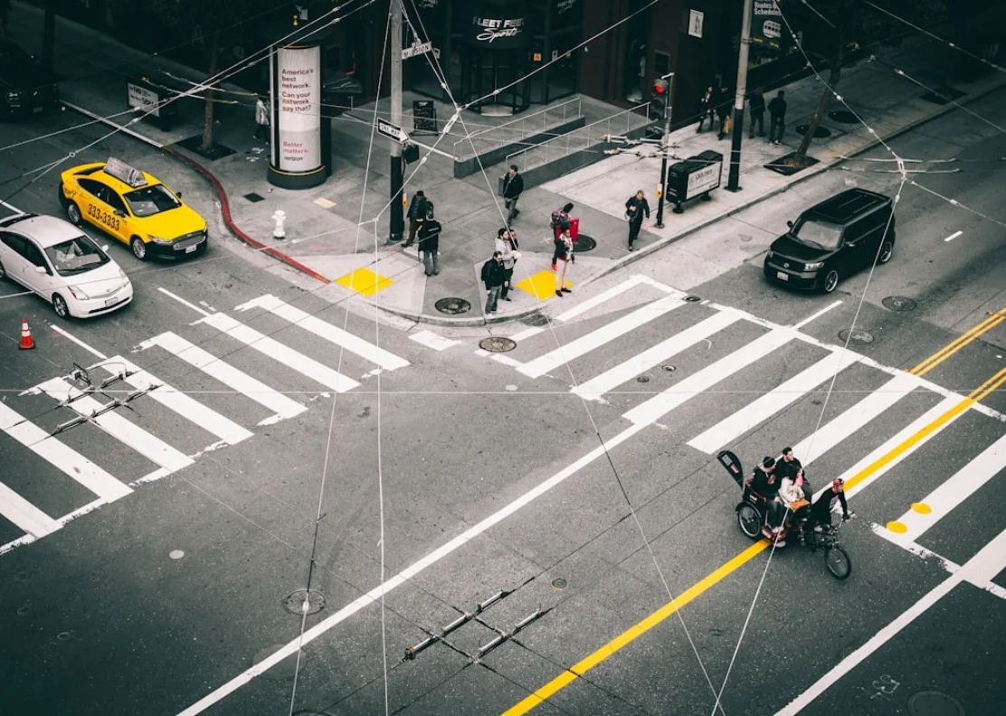
Modern intersections carry vehicles, cyclists, and pedestrians simultaneously — demanding a counting solution that handles all three
Traditional traffic counters were designed for vehicles on arterials. Today’s cities need data on every road user, at every intersection — to plan safer streets, optimise signal timing, justify infrastructure investment, and measure the impact of changes over time.
Why Intersections Are the Most Important Data Point in Your Network
If you want to understand how a city moves, you study its intersections. They are the decision points of the network — where routes converge, where conflicts between road users occur, where signal timing determines flow efficiency, and where the safety consequences of poor design are most acute.
Yet despite their importance, most intersections are monitored by technology that captures only a fraction of what’s happening. Inductive loop detectors count vehicles in specific lanes but can’t see pedestrians at all. Video cameras struggle in darkness, rain, and glare. Pneumatic tubes count axles on one approach at a time. None of these tools gives a traffic engineer a complete, simultaneous picture of all road users at all approaches — which is exactly what modern active transportation planning demands.
Signal Timing Optimisation
Accurate turning movement counts for all road user types — not just vehicles — are the foundation of evidence-based signal timing. Pedestrian and cyclist phase allocation depends on knowing actual demand.
Active Transportation Planning
Protected cycling infrastructure, pedestrian priority signals, and crosswalk upgrades all require baseline counts and trend data that traditional vehicle-only sensors cannot provide.
Safety Analysis & Conflict Detection
Near-miss events between road users are invisible to traditional sensors. LiDAR tracks simultaneous trajectories, enabling conflict point analysis without relying on collision reports after the fact.
Before & After Studies
Infrastructure investment requires proof. Continuous intersection data makes before-and-after comparisons rigorous — showing exactly how a protected lane, redesigned crosswalk, or signal change affected all road user volumes.
Transit Priority & Coordination
Bus and tram priority systems need accurate real-time vehicle classification to distinguish transit vehicles from private cars. LiDAR provides the classification precision that simple detection systems lack.
Funding & Grant Justification
Federal and provincial active transportation funding increasingly requires documented multimodal counts. LiDAR-derived data provides the auditable, continuous evidence base that project applications demand.
Why Cameras and Radar Fall Short at Modern Intersections
Before examining what LiDAR offers, it’s worth understanding why the two most common alternatives — video cameras and radar — have not solved the multimodal counting problem despite being widely deployed.
Video Cameras — Limited by Light and Weather
Camera-based counting systems have improved significantly with AI-powered video analytics, but they remain fundamentally constrained by their dependence on visible light. Performance degrades in darkness, headlight glare, rain, snow, fog, and direct sun on the lens. A camera that performs well on a clear summer afternoon may produce unreliable data during a February rush hour. In Canada, this is not an edge case — it is a significant portion of your annual data collection window.
Radar — Excellent for Vehicles, Poor for Vulnerable Road Users
Radar excels at detecting and classifying vehicles — particularly at highway speeds — and performs well in adverse weather. However, radar struggles to reliably detect pedestrians and cyclists, whose smaller radar cross-sections and slower speeds make them difficult to distinguish from environmental clutter. For multimodal intersection counting, radar alone is not a complete solution.
Loop Detectors & Tubes — Single Mode, Single Approach
Inductive loops and pneumatic tubes count vehicles in specific lanes or on specific approaches. They provide no information about pedestrians, cyclists, or turning movements. They require road cuts or temporary lane closures to install, cannot be repositioned, and provide no spatial data about road user behaviour beyond presence/absence detection.
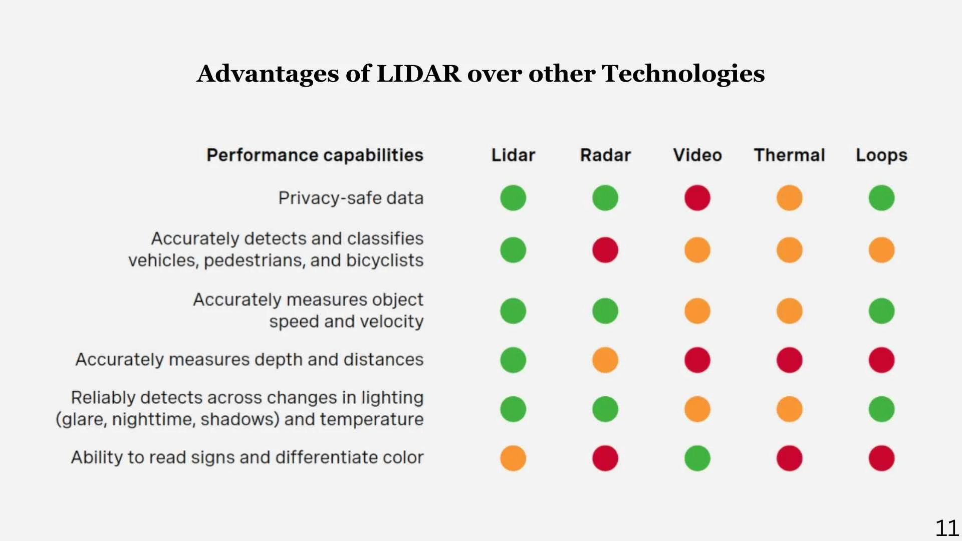
LiDAR outperforms camera and radar across all weather conditions and all road user types
How LiDAR Sees an Intersection
LiDAR works by emitting rapid pulses of laser light and measuring the time it takes for each pulse to return after reflecting off an object. By doing this millions of times per second across a wide field of view, it builds a continuous, high-resolution 3D point cloud of everything in its detection zone — regardless of ambient lighting.
At an intersection, a single LiDAR unit mounted on a pole or signal mast can cover all approaches simultaneously. Every moving object in the scene — a car turning left, a cyclist filtering to the front, a pedestrian mid-crossing — is tracked as a unique object with its own position, velocity, heading, and trajectory. AI-powered classification algorithms then assign each object to a road user category in real time.
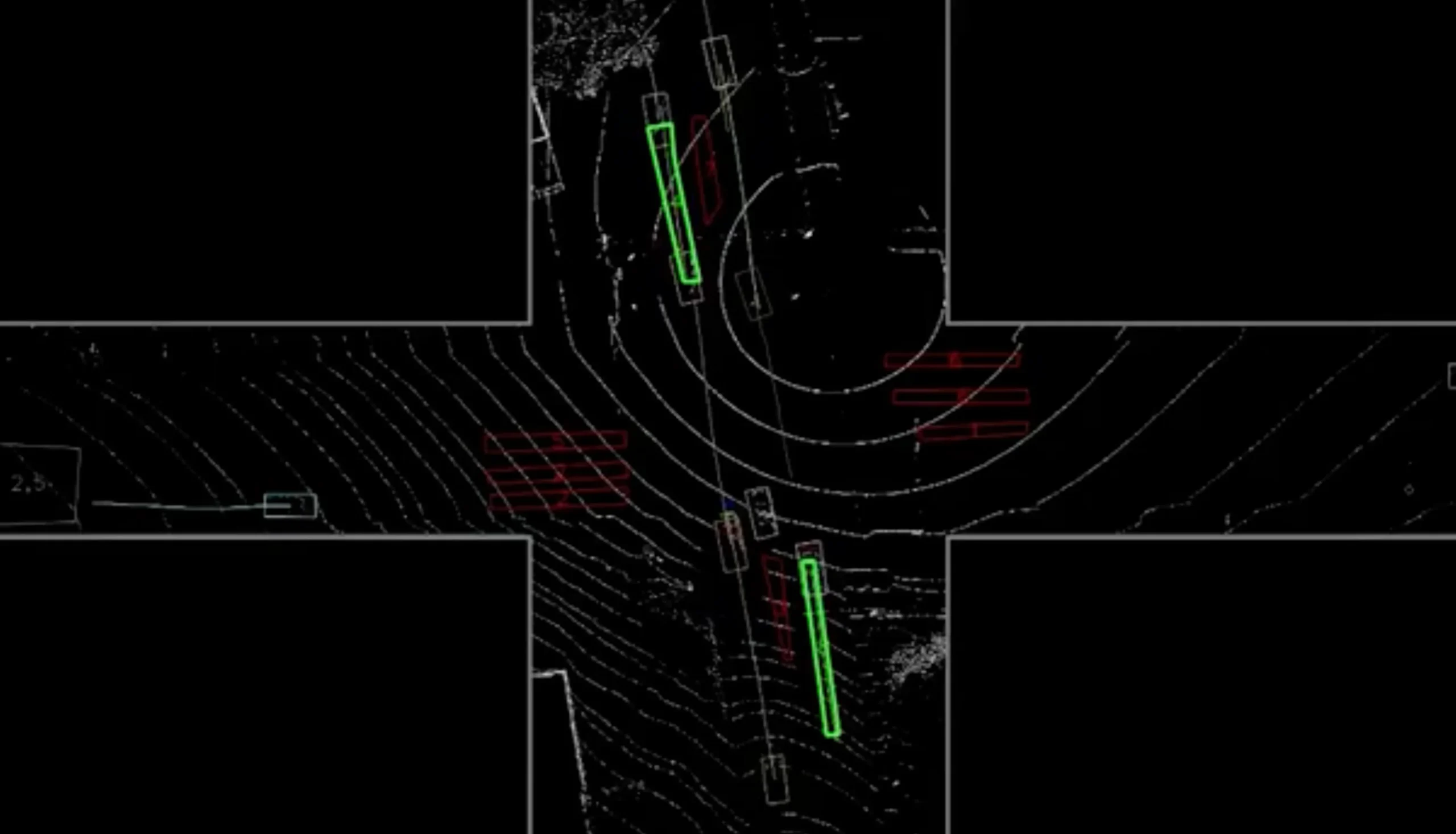
LiDAR generates a live 3D point cloud of the intersection — every road user tracked simultaneously by type, speed, and trajectory
The result is a continuous stream of structured data: vehicle counts by lane and turning movement, pedestrian crossing volumes by crosswalk and direction, cyclist counts with speed and lane position, and conflict point detection when trajectories intersect dangerously. All of this from a single sensor installation, operating 24 hours a day, 365 days a year, in any weather condition.
Unlike cameras, LiDAR does not capture images — it captures geometry. This means it is inherently privacy-compliant: no faces, no licence plates, no identifying visual information is ever recorded. You get precise movement data with zero privacy exposure — a critical advantage for public-space deployment.
What Data a LiDAR Intersection System Delivers
The data output from a LiDAR intersection system goes far beyond simple volume counts. Here is what traffic engineers and transportation planners can access from a single deployment:
Turning Movement Counts by Vehicle Class
Full turning movement counts for all approaches — left, right, through — broken down by vehicle classification (passenger cars, light goods vehicles, heavy trucks, buses, motorcycles). Replaces manual TMC studies with continuous automated data.
Pedestrian Volume & Crossing Behaviour
Pedestrian counts per crosswalk per direction, with crossing time data, pedestrian waiting time, and detection of non-compliant crossing behaviour. Essential for pedestrian signal phase allocation and crosswalk safety assessment.
Cyclist Counts with Lane Position & Speed
Bicycle volumes per approach and per direction, with lane position data (in bike lane, in vehicle lane, on sidewalk) and speed metrics. Supports cycling infrastructure planning, contraflow assessment, and before/after studies.
Conflict Point Detection
When two road user trajectories come within a defined proximity threshold, the system flags a conflict event — logging the time, location, road user types, and speeds involved. This enables proactive safety analysis without waiting for collision data.
Speed, Queue Length & Delay
Vehicle speed profiles per approach, queue length over time, and intersection delay metrics. Feeds directly into signal optimisation models and level-of-service assessments for transportation impact studies.
Cloud Dashboard & Exportable Reports
All intersection data is aggregated in a cloud-based dashboard with configurable reporting periods, export to standard traffic engineering formats, and API access for integration with city traffic management systems and third-party platforms.
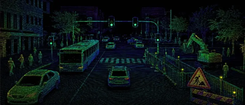
Cloud-based analytics dashboard — turning movements, classifications, and pedestrian volumes in one view

One Sensor. Complete Intersection Coverage.
Our LiDAR intersection counting systems are built for permanent outdoor deployment — weatherproof, compact, and designed for pole or mast mounting at standard intersection heights. A single unit provides 360° coverage with a detection range of up to 40 metres, covering all approaches of a standard urban intersection simultaneously.
The sensor connects to a cloud-based data platform via cellular or fibre, with edge computing capability for real-time processing and local data retention as backup. No road cuts, no lane closures, no infrastructure disruption — installation is a matter of hours, not days.

A single LiDAR unit covers all approaches, crosswalks, and turning lanes simultaneously
Who Uses LiDAR Intersection Data — and Why
LiDAR intersection systems serve a wide range of stakeholders across transportation planning, traffic operations, and public safety — each with different data needs but a shared requirement for accuracy and reliability.
🏙️ Municipal Transportation Departments
Continuous multimodal counts for signal timing optimisation, active transportation planning, and road safety programs. Replaces expensive periodic manual studies with permanent automated monitoring.
🚦 Traffic Engineering Consultants
High-quality turning movement count data for transportation impact assessments, intersection capacity analysis, and development applications — collected continuously rather than in short manual count windows.
🚌 Transit Agencies
Intersection-level data to support transit signal priority systems, bus rapid transit planning, and the documentation of transit delay caused by intersection congestion and pedestrian conflict.
🏗️ Developers & Planners
Before-condition baseline data for development applications, and post-construction monitoring to demonstrate compliance with traffic impact mitigation commitments.
🚴 Active Transportation Advocates
Objective cyclist and pedestrian volume data to support infrastructure investment proposals, demonstrate demand for protected lanes and pedestrian priority signals, and measure program effectiveness.
🔬 Road Safety Programs
Conflict point data and near-miss event logs for proactive safety interventions — identifying dangerous intersection geometries before collisions occur rather than after.
“LiDAR provides the best accuracy in comparison to radar and camera — for indoors and outdoors, with 360° coverage, the highest accuracy for counting pedestrians, cyclists, and vehicles from a single sensor.”
— Smart Sensor Solutions, Traffic Counting Solutions
Why Cities Are Choosing LiDAR for Intersection Monitoring
The shift toward LiDAR-based intersection monitoring reflects a broader recognition that the data needs of modern transportation planning have outgrown the capabilities of legacy counting technology.
- All road users in one deployment — vehicles, pedestrians, and cyclists counted simultaneously from a single sensor, eliminating the need for separate counting programs per mode
- Weather and lighting independent — reliable data in rain, snow, fog, darkness, and glare that would degrade camera performance
- Privacy compliant by design — no images captured, no faces or licence plates recorded, no personal data at risk
- Continuous 24/7 operation — replaces periodic manual counts with permanent automated monitoring at a lower long-term cost
- Turning movement data included — directional counts for all approaches without manual observation or separate detection per lane
- Conflict detection capability — proactive safety intelligence beyond what any volume-counting technology can provide
- Non-intrusive installation — pole or mast mounting with no road cuts, no lane closures, and minimal disruption to intersection operations
- Cloud-based data access — real-time and historical data accessible from any device, with export to standard traffic engineering formats
A single LiDAR sensor at an intersection delivers more useful, more accurate, and more actionable data than a combination of loop detectors, pneumatic tubes, and periodic manual counts — at a lower total cost of ownership over a three-to-five year horizon.
Ready to Count Every Road User at Every Intersection?
Whether you’re planning a pilot deployment, scoping a network-wide program, or replacing an ageing counting system — we’re ready to help you design the right solution.