Parking Is a Data Problem.
LiDAR Is the Solution.
Real-time occupancy monitoring, accurate vehicle counting, and driver guidance for campuses, airports, hospitals, and large facilities — without embedded sensors, roadway cuts, or counting drift.
Every facility manager who oversees a large parking operation knows the scenario: drivers circling lots they believe are full when spaces are available in the next section, congestion backing up to the street during peak periods, and staff fielding complaints that the guidance system shows capacity when the lot is clearly open. The parking system isn’t broken — it’s just working with bad data.
Parking operations at scale — campuses, airports, hospitals, urban commercial properties, transit facilities, event venues — require continuous, accurate occupancy data to function well. When that data is unreliable, every downstream decision suffers: signage guides drivers to the wrong location, operational staff can’t anticipate demand peaks, and facility planners make infrastructure decisions based on occupancy estimates rather than facts.
The root cause is almost always the technology at the centre of the system. Traditional parking counting relies on embedded loop detectors, entry/exit gate transactions, or point sensors at lane boundaries. These technologies were designed for simpler, more controlled environments. In real-world conditions — wide lanes, complex vehicle movements, seasonal weather, high-volume mixed traffic — they accumulate counting errors that compound over time into occupancy drift that renders the entire system unreliable.
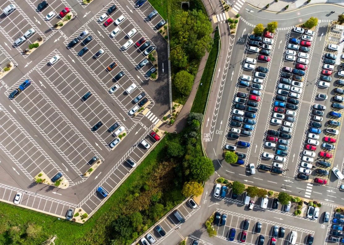
Large-scale parking environments demand real-time, accurate occupancy data — not periodic estimates
Parking occupancy errors don’t stay small. A 2% counting error at a 1,000-space facility means 20 spaces of drift per counting cycle. By mid-day, your system may be showing 340 available spaces when the true figure is 280 — or showing full when 60 spaces are open. Inaccurate data doesn’t just frustrate drivers. It erodes trust in the entire guidance system.
Why Traditional Parking Counting Systems Fall Short
The limitations of legacy parking counting technology are well understood by anyone who has operated a large facility for more than a few years. The problems are not random — they are structural, stemming from the fundamental design constraints of each technology type.
Inductive Loop Detectors — Accurate Until They’re Not
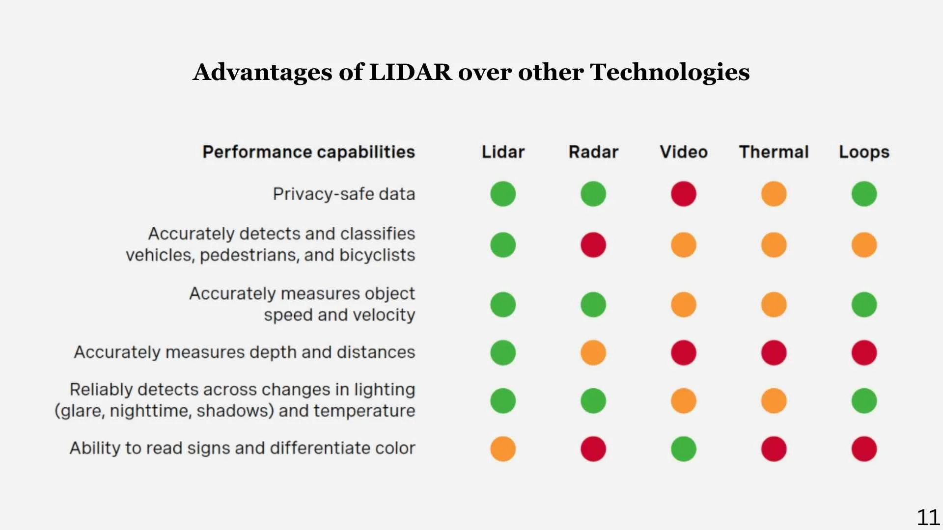
Loop detectors cut into the roadway pavement work reliably in controlled lane configurations but are sensitive to vehicle positioning, degraded by road surface wear, and require traffic disruption to install or replace. In wide lanes or mixed-use entrances, vehicles straddling loops or entering at oblique angles produce miscounts that accumulate silently over hours and days.
Gate Transaction Data — Only as Good as Compliance
Entry/exit gate counts assume every vehicle triggers the gate on entry and exit. In facilities with tailgating, barrier failures, staff vehicles, emergency access, or pedestrian interference, gate transaction data systematically undercounts or creates orphaned transactions that corrupt occupancy calculations over time.
Point Sensors & Beam Breaks — Single Points of Failure
Infrared or ultrasonic beam-break sensors at lane boundaries are low cost but highly sensitive to misalignment, dirt accumulation, and weather. A single misaligned sensor at a busy entrance can generate hundreds of false counts per day — and because the failure is silent, it may go undetected for weeks.
Camera-Based Counting — Limited by Lighting and Weather
Video analytics for parking counting has improved, but camera performance degrades significantly in darkness, headlight glare, snow, rain, and direct sun — conditions that represent a significant fraction of operational hours at any Canadian facility. Accuracy that meets specification in ideal conditions often falls well short during the peak winter months when reliable occupancy data matters most.
LiDAR mounts overhead — no pavement cuts, no traffic disruption, no maintenance access requirements
How LiDAR-Based Counting Works — and Why It’s Different
LiDAR — Light Detection and Ranging — builds a continuous, real-time 3D map of its detection zone by emitting millions of laser pulses per second and measuring the precise distance to every object they reflect off. Unlike a point sensor that asks “did something break my beam?”, LiDAR asks “what is in my field of view, where exactly is it, how large is it, and where is it going?”
At a parking facility entrance, a single LiDAR unit mounted above the lane — on an overhead arm, a canopy, or a nearby pole — can monitor multiple lanes simultaneously without any roadway intervention. Every vehicle entering or exiting is tracked as a unique three-dimensional object from the moment it enters the detection zone to the moment it leaves. Its direction, speed, size class, and lane position are all captured in real time.
Because the system tracks objects rather than counting interruptions, it handles the scenarios that defeat traditional sensors: vehicles stopping mid-lane, multiple vehicles in close succession, wide vehicles spanning lane boundaries, pedestrians crossing the entrance, cyclists, and vehicles reversing. None of these scenarios produce false counts — the system simply tracks what is actually present and moving.
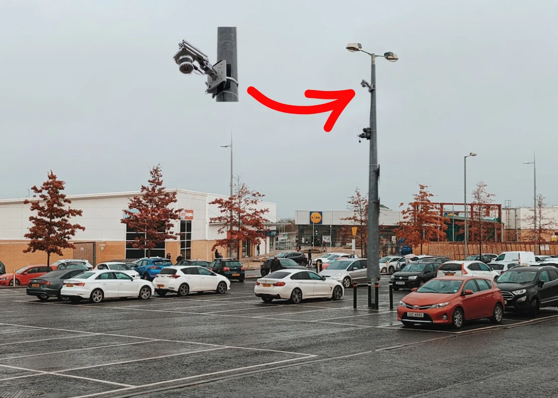
LiDAR mounted overhead monitors multiple lanes simultaneously — day and night, in any weather
LiDAR operates independently of ambient lighting and maintains performance in rain, snow, fog, and glare conditions that would degrade camera accuracy. For Canadian facilities, this is not a minor feature — it is a fundamental operational requirement. Your parking system needs to work reliably in February, not just July.
What a LiDAR Parking System Actually Delivers
The value of LiDAR-based parking management extends well beyond accurate entry and exit counts. Here is what a fully deployed system delivers across the operational, analytical, and user experience dimensions of parking management.
Real-Time Occupancy by Lot, Level, and Zone
Continuous occupancy counts updated in real time for every monitored entrance and exit. Operators can see current available spaces at the lot level, parking structure level, or individual zone level — from a central dashboard, on a mobile device, or via API integration with existing facility management systems.
Vehicle Classification
LiDAR differentiates vehicles by size class — passenger cars, light trucks and SUVs, large vehicles, motorcycles, and commercial vehicles — enabling separate occupancy tracking for reserved zones, accessible spaces, oversized vehicle areas, and permit-controlled sections.
Dynamic Guidance Signage Integration
Real-time occupancy data feeds directly into dynamic entry signage and wayfinding displays — showing drivers available space counts before they enter and directing them to the most appropriate lot or level. This reduces circulating traffic, eliminates unnecessary congestion, and dramatically improves the driver experience during peak periods.
Traffic Flow & Queue Monitoring
Beyond occupancy, LiDAR tracks vehicle queuing at entrances, internal circulation patterns, and bottleneck formation in real time. Operators can see queue length building before it reaches the public road and respond proactively — opening additional lanes, redirecting traffic, or deploying staff to manage flow.
Operational Analytics & Historical Reporting
Every occupancy data point is stored and accessible for historical analysis. Peak demand periods, lot utilisation patterns, dwell time distributions, and turnover rates are all reportable over any time range. This is the data that drives smarter decisions about operating hours, staffing levels, pricing strategies, and future infrastructure investment.
API Integration with Smart City & Mobility Platforms
LiDAR parking data integrates via open APIs with smart city platforms, mobile parking apps, enforcement systems, event management tools, and shuttle coordination systems — making it a live data source for the broader mobility ecosystem rather than an isolated operational tool.
The Driver Experience — From Frustration to Confidence
The most visible impact of a well-implemented smart parking system is the change in driver behaviour. When guidance is accurate, drivers follow it. When guidance is wrong — even occasionally — drivers stop trusting it and default to circling, which creates exactly the congestion the system was meant to prevent.
Accurate real-time data from LiDAR counting makes dynamic guidance reliable. A sign showing 47 available spaces in Lot B means exactly that — because the underlying count is continuously updated and verified, not estimated or drifting. Drivers arrive at their destination confident they will find a space. Peak-period congestion at entrances reduces because vehicles are distributed across available capacity rather than converging on lots they believe are open.
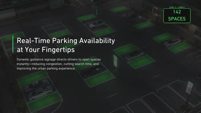
Accurate real-time occupancy data makes dynamic guidance reliable — drivers follow it when they trust it
Facilities that deploy accurate real-time parking guidance consistently report measurable reductions in circulation traffic, entrance congestion, and driver complaints — along with improved utilisation of secondary and overflow lots that were previously underused because drivers didn’t trust the guidance system enough to go there.
From Operational Data to Strategic Intelligence
The case for LiDAR parking management doesn’t rest on real-time operations alone. The historical data a continuously operating system generates over months and years is equally valuable — and often more so for the decisions that shape long-term facility planning.
Occupancy trend data reveals which lots are consistently over- and under-utilised, and at what times. Peak demand analysis identifies the specific hours, days, and seasonal patterns that drive congestion — enabling staffing and operational decisions based on evidence rather than assumption. Vehicle flow analytics show how traffic distributes across a campus or facility, where bottlenecks form, and where circulation road changes would have the highest impact.

Historical analytics — peak demand, utilisation trends, and flow patterns for smarter planning decisions
For event venues and facilities with variable demand — hospitals managing visitor peaks around visiting hours, campuses managing the academic calendar, airports managing seasonal travel patterns — this analytics layer is what turns a parking counting system into a genuine operational planning tool.
Where LiDAR Parking Management Delivers the Most Value
🏫 University & College Campuses
Large distributed parking across multiple lots, variable demand by academic schedule, permit zones, accessible parking compliance, and event overflow management. LiDAR handles the complexity that defeats simpler systems.
✈️ Airports & Transit Hubs
Multi-level parking structures, high-volume entrances, mixed vehicle types, and 24-hour operation. Accurate occupancy data feeds passenger guidance systems and supports revenue management at busy periods.
🏥 Hospitals & Healthcare Facilities
Emotional, time-sensitive visitors who cannot afford to circle. Reliable guidance to available spaces — including accessible parking zones — is not just operational efficiency, it is patient experience management.
🏢 Commercial & Mixed-Use Properties
Shared parking across tenants with variable peak periods, reserved zone management, and visitor versus employee allocation. Real-time data enables dynamic allocation that maximises utilisation without over-provisioning.
🏟️ Event Venues & Stadiums
Extreme demand peaks followed by rapid egress. LiDAR tracking of vehicle queues and lot fill rates enables event staff to manage flow in real time — preventing the entrance congestion that causes the worst post-event experience.
🏙️ Municipal Parking Operations
Downtown parking structures and surface lots where accurate occupancy data supports dynamic pricing, mobile app integration, and the enforcement data that keeps permit zones functioning as designed.
“Parking is no longer just about counting cars. It is about understanding how vehicles move through your facility, predicting demand before it peaks, and giving every driver the confidence that the guidance they see is accurate.”
— Smart Sensor Solutions
Why Facility Operators Are Choosing LiDAR Over Legacy Systems
- No roadway installation — overhead mounting eliminates pavement cuts, lane closures, and ongoing maintenance access requirements
- Multi-lane coverage from one sensor — reduces hardware count and infrastructure complexity versus single-lane point sensors
- All-weather reliability — operates in rain, snow, fog, darkness, and glare conditions that degrade camera-based systems
- Vehicle classification included — separate tracking for passenger vehicles, oversized vehicles, motorcycles, and accessible parking zones
- Real-time occupancy with no drift — continuous tracking prevents the count accumulation errors that affect loop detector and gate-based systems
- Dynamic signage ready — real-time data feeds directly to parking guidance displays via standard API integration
- Historical analytics included — peak demand, utilisation trends, dwell time, and flow analysis for operational and planning decisions
- Scalable across large facilities — add sensors to additional entrances, levels, or lots without redesigning the core system
- Privacy compliant — no images captured, no licence plate data recorded, no personal information at risk
A LiDAR-based parking management system costs more upfront than a basic loop detector installation. Over a three-to-five year horizon — accounting for maintenance, accuracy, scalability, and the operational value of reliable analytics — it consistently delivers a lower total cost of ownership and significantly better operational outcomes.
Ready to Modernise Your Parking Operations?
Whether you manage a campus, hospital, airport, event venue, or municipal facility — we can design a LiDAR parking solution that fits your environment, your budget, and your operational objectives.
Serving facilities across Canada and the United States · Tel: +1 (855) 613 4486 · info@smartsensrsolutions.com